Application of Unmanned Aerial Vehicles/ Drones in Precision Agriculture
Manish Kumar Vishwakarma*, Karthikeyan Thiyagarajan and Pradeep Kumar Bhati
July 2nd 2025, 1:17:05 am | 5 min read

Abstract :
Weather, soil conditions, and temperature are pivotal external elements influencing agricultural outcomes. With the aid of agricultural drones, farmers gain the ability to respond to specific environmental nuances and make informed decisions. Leveraging the acquired data, they can effectively manage crop health, conduct precise crop scouting, implement targeted crop treatments, regulate irrigation, and perform thorough field soil analysis and crop damage assessments. Consequently, drone surveys not only enhance crop yields but also streamline operations, reducing both the time and costs involved in the farming process.
Introduction :
The rapid expansion of drone utilization across diverse industries is undeniable, with a particularly notable surge in its adoption within the agricultural sector. Current projections suggest a substantial escalation in the agricultural drone market, soaring from $1.2 billion (USD) in 2019 to an anticipated $4.8 billion by 2024. This burgeoning trend foresees an imminent ubiquity of drone applications, ranging from surveillance to fortification, on both extensive and compact farming enterprises. Undoubtedly, the timelines of the research outcomes have been influenced by the relatively delayed emergence of the term Unmanned Aerial Vehicles "UAV," considering the existence of prior studies on autonomous helicopters conducted by Gilmore at the Georgia Institute of Technology as early as 1984 (Gilmore 1984). Consequently, the prevalent use of the term "autonomous helicopter" persisted until 2015 when the more commonly employed term "drone" began to gain prominence about unmanned aircraft.
The assimilation of data procured by drones on agricultural lands holds paramount significance, serving as a catalyst for informed decision-making in the realm of agronomy (del Cerro et al. 2021). This assimilation plays an integral role within the framework of what is commonly referred to as 'precision agriculture.' In numerous agricultural domains, the integration of drone technology has already evolved into an indispensable component of large-scale precision farming mechanisms (Figure 1). The invaluable data garnered from drone-assisted field surveillance aids farmers in devising meticulous strategies for optimal planting and meticulous treatments, thereby maximizing crop yields. Reports have underscored that the incorporation of precision farming systems has the potential to elevate yields by a noteworthy 5%, a significant enhancement within an industry characterized by typically slender profit margins. We endeavour to delve into the present applications of drone technologies widespread within the agricultural framework.

Figure 1: Utility of drones in different agriculture sectors for the precision agriculture
Monitoring Plant Health
The application of drone imagery has witnessed successful implementation in various domains, notably in the realm of monitoring plant health. Drones, equipped with specialized imaging technology known as Normalized Difference Vegetation Index (NDVI), utilize intricate colour data to assess the state of plant health. This capability empowers farmers to oversee crop development, enabling swift intervention in the event of any issues to salvage the crops. A clear demonstration of the functionality of NDVI is portrayed in this image (Figure 2). Notably, aerial vehicles were not exclusively employed for physical treatments in agriculture. Documented works dating back to the 1930s, along with applications since the 1950s, illustrate the utilization of infrared aerial photography via planes for identifying diminished vitality in wheat and other small grains resulting from various diseases (Colwell et al. 1956).
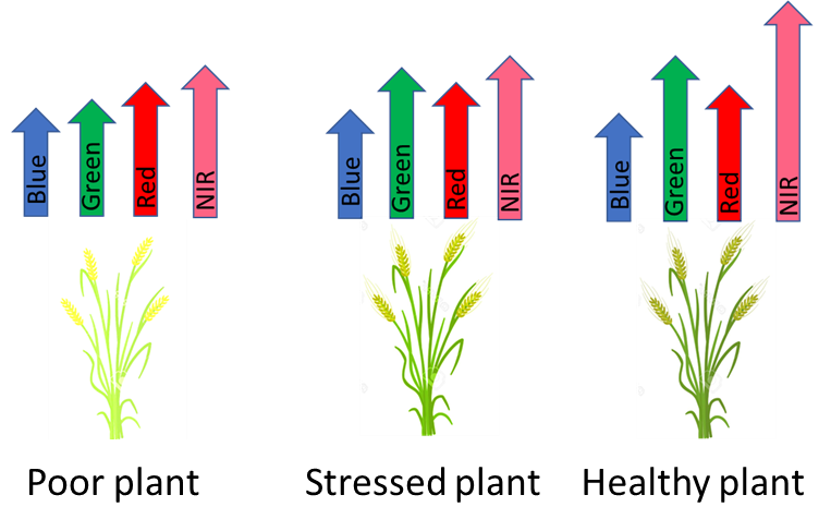
Figure 2: Crop health monitoring through drone
Moreover, drones fitted with standard cameras are employed for crop health surveillance as well. While many farmers currently rely on satellite imagery to track crop growth, density, and color variations, the accessibility of satellite data proves to be expensive and less effective compared to the detailed imaging provided by drones in many scenarios. The proximity of drones to the fields renders them less susceptible to the limitations posed by cloud cover and unfavorable lighting conditions, often encountered in satellite imaging. While satellite imaging offers accuracy up to the meter, drone imaging excels with its capability to pinpoint image locations down to the millimetre. This precise capability facilitates the identification of areas with gaps post-planting, enabling timely re-planting as necessary. Furthermore, it aids in the prompt detection and treatment of disease or pest infestations.
Monitoring field conditions, soil and weed management
Drone field monitoring has extended its utility to encompass the assessment of soil health and field conditions. Leveraging the capabilities of drones, farmers can access precise field mapping, inclusive of elevation data, facilitating the identification of any inconsistencies within the terrain. Acquiring comprehensive field elevation information proves instrumental in discerning drainage patterns and identifying areas prone to moisture accumulation, thus enabling the implementation of more efficient irrigation methodologies. Certain vendors and service providers specializing in agricultural drone technology offer advanced sensors for monitoring nitrogen levels within the soil. This integrated approach facilitates the accurate application of fertilizers, effectively addressing suboptimal growth regions and fostering long-term improvements in soil vitality. The optimization of herbicide application within a crop field necessitates the availability of precise weed maps. However, the task of detecting weeds during the early phenological stages, especially when both crop and weed plants share similar spectral and visual characteristics, poses a formidable challenge (Lopez Granaods et al. 2016).
Planting and Seeding
Certainly, historical accounts and reputed sources indicate that the initial recorded instance of aerial agricultural material application took place in 1906, credited to John Clervaux Chaytor. Chaytor conducted the dispersion of seeds across a waterlogged valley floor in Wairau, New Zealand, utilizing a hot air balloon with movable tethers at the family farm known as "marshlands." Subsequently, in 1921, the US Agriculture Department and the US Army Signal Corps research station in Ohio employed an aircraft for crop dusting (Johnson et al. 2002).
A relatively recent and less common application of drones in the realm of agriculture involves their utilization for seed planting purposes. While automated drone seeders currently find primary usage within the forestry sector, there exists promising potential for their more extensive deployment shortly. The introduction of drone-based planting signifies a viable solution for reforesting challenging and remote terrains without subjecting labourers to potential hazards by wild animals. Moreover, the efficiency of drone-based planting operations is noteworthy, as evidenced by a team comprising two operators and ten drones, collectively capable of seeding up to 400,000 trees within a single day.
Spray Application
The benefits derived from utilizing aerial services in agriculture prompted their extension to additional tasks, including top dressing, which entailed the aerial application of fertilizers over farmlands, a practice that gained prominence in 1940. In Southeast Asia, the widespread adoption of drones for the application of spray treatments has gained significant momentum, particularly in South Korea, where approximately 30% of agricultural spraying operations are conducted using drone technology. Drones designed for spraying purposes exhibit exceptional navigational capabilities, enabling access to arduous terrains such as steep tea fields situated at elevated altitudes. By assuming the responsibility of field spraying tasks, drone sprayers mitigate the risks associated with manual backpack sprayer operations, which pose potential hazards to the health of workers. The precise and fine spray application delivered by drone sprayers facilitates targeted treatments tailored to specific areas, maximizing operational efficiency and curbing chemical expenditure. Notably, regulations governing drone sprayer usage exhibit substantial discrepancies across different countries. In Canada, the current legal framework does not permit the operation of drone sprayers, necessitating further comprehensive assessments to comprehend the implications of spray drift. Several regulatory proposals advocate for the engagement of solely trained professionals in piloting spray drones, a practice aligned with the operational model of Yamaha, which refrains from directly selling the spray drones they manufacture. Instead, they provide lease-based spray drone services inclusive of licensed operators.
Drone Pollination
Several innovative applications of drone technology in agriculture are currently undergoing rigorous testing and developmental stages. Notably, the concept of pollinating drones has garnered considerable attention, although it has often been subject to fictionalized portrayals. Ongoing research endeavours in the Netherlands and Japan centre around the development of compact drones specifically engineered for pollination, demonstrating the capacity to pollinate plants effectively without causing any harm. The immediate focus lies in the advancement toward autonomous pollinating drones, which would operate seamlessly and monitor crop health autonomously, thereby reducing the necessity for continuous manual intervention from operators.
Monitoring Irrigation
Drones equipped with a range of advanced sensors, such as hyperspectral, thermal, or multispectral sensors, play a pivotal role in identifying regions within agricultural landscapes that exhibit signs of inadequate moisture or require intervention from the farmer. Through comprehensive drone surveys, farmers can enhance water utilization efficiency and unveil potential issues such as water pooling or leaks within irrigation systems. These surveys provide crucial insights into irrigation monitoring, enabling the computation of vegetation indices that offer valuable indicators of crop health, alongside the identification of heat and energy emissions.
Monitoring Livestock
Drone surveys have transformed farming practices, enabling farmers to oversee livestock monitoring. With the integration of thermal sensor technology, drones aid in the swift location of missing animals and the early identification of any signs of injury or illness. This dual functionality of drones significantly contributes to enhancing overall vegetation production, making them an indispensable tool for modern agricultural practices.
Assessment of crop loss
Valuable for insurance claims, the data gathered via drones is instrumental for farmers when filing for crop insurance following any potential damages. They leverage this information to accurately assess the risks and losses pertaining to their land, ensuring a comprehensive understanding of their insurance coverage. The agricultural insurance industry employs agricultural drones to acquire reliable and efficient data. These drones capture precise information regarding damages, facilitating accurate estimations for monetary compensation to the farmers.
Artificial intelligence (AI) with drone
Advancements in drone technology are also closely tied to the progress of machine learning applications. Enhancing the capabilities of artificial intelligence (AI) within drones holds pivotal significance, particularly in the context of catering to the needs of small-scale farmers in developing nations. Existing drone technologies primarily excel in the monitoring of widely cultivated crops. However, current drone monitoring systems encounter challenges in identifying regions characterized by a diverse range of crops, less familiar agricultural produce, and grains that bear a resemblance throughout various stages of growth. Consequently, these systems exhibit diminished effectiveness in the surveillance of crop development and overall plant health within such contexts. To address this limitation, concerted efforts are necessary to facilitate the training of AI systems, enabling them to proficiently discern less prevalent crops and more intricate planting patterns.
UAV Flying Regulation for Agricultural Tasks
Employing unmanned aerial vehicles (UAVs) in both commercial and private agricultural operations mandates adherence to specific legal protocols, necessitating growers to familiarize themselves with the intricate rules and regulations, thereby adding to their learning requisites. The integration of UAVs equips growers with the capability to make well-informed decisions, with autonomous flight functionalities enabling a more expedient, efficient, and superior sowing process compared to traditional methods. By significantly reducing uncertainties and ambiguities in various agricultural procedures, drone technology has facilitated the establishment of a harmonious relationship between technological advancements and conventional farming practices. Despite the numerous benefits associated with drone deployment in agriculture, cost remains a substantial concern. Nevertheless, the competitive landscape among drone manufacturers has contributed to a gradual reduction in drone prices, ultimately paving the way for widespread accessibility of drone technology among farmers worldwide.
Conclusion :
The agricultural sector has undergone a significant transformation owing to the widespread integration of drone technology, with projections indicating further substantial growth in the foreseeable future. While the utility of drones is increasingly recognized among small-scale farmers, the widespread adoption of this technology across all agricultural domains, especially in developing nations, remains a work in progress. Additionally, comprehensive research endeavours are imperative to evaluate the efficacy of drones in specific tasks, such as pesticide application and spraying. Crop health assessment is significantly enhanced through the deployment of drones, which are equipped with specialized sensors capable of detecting infrared radiation. This enables the timely identification of fungal, bacterial, or other diseases, often even before they become visible to the human eye. By utilizing multispectral cameras, drones can produce highly accurate images, facilitating the early detection of diseases and consequently saving valuable time and resources for farmers. In the domain of irrigation management, drones prove instrumental in simplifying the inspection and correction of multiple irrigation points across expansive and undulating farmlands, thereby ensuring optimal water distribution. Furthermore, drones aid in the creation of weed maps, enabling farmers to identify areas of intense weed proliferation and distinguish healthy crops from unwanted growth, thus streamlining the process of selective weed removal. Leveraging drone-generated data, farmers can devise customized nutrient application maps, optimizing fertilizer distribution based on the specific nutrient requirements of different crop zones. Additionally, drones facilitate precise yield estimation by efficiently counting crop heads and gauging their volume, thereby providing farmers with a more accurate assessment of their potential yield compared to manual calculations. The establishment and refinement of regulatory frameworks governing drone usage represent a crucial step that necessitates attention and action in numerous countries. Although drones offer diverse benefits to farmers, it is vital to comprehend their inherent limitations and functionalities before committing to the investment in sophisticated equipment.
References:
Colwell, R.N. (1956). Determining the prevalence of certain cereal crop diseases using aerial photography. Hilgardia. 26, 223–286.
del Cerro, J., Cruz Ulloa, C., Barrientos, A., de León Rivas, J. (2021).
Unmanned Aerial Vehicles in Agriculture: A Survey. Agronomy. 11, 203. https://doi.org/10.3390/agronomy11020203
Gilmore, J. (1984). The autonomous helicopter system. In Proceedings of the Society of Photo-Optical Instrumentation Engineers, Arlington,
VA, USA, 14 June 1984; Volume 485, pp. 146–152.
Johnson, A.A., McCook F. (1927). Landfall Press: Dayton, OH, USA, 2002; pp. 190–191; ISBN 0-913428-84-1.
López-Granados, F., Torres-Sánchez, J., Serrano-Pérez, A., de Castro,
A.I., Mesas-Carrascosa, F.J., Pena, J.M. (2016). Early season weed mapping in sunflower using UAV technology: Variability of herbicide treatment maps against weed thresholds.
Precis. Agric., 17, 183–199.
Sugeno, M., Hirano, I., Kotsu, S. (1995). Development of an intelligent unmanned helicopter. In Proceedings of the 1995 IEEE International
Conference on Fuzzy Systems, Yokohama, Japan, 14–20 March 1995; Volume 5, pp. 33–34.